Sea Lion Caves smell like fish, which is nice for those of us who like the smell of fish.
But permit me to begin at the beginning as we make our twisty-turny way down Highway 101 on the Oregon Coast, looking out at the remote horizon, compensating for inertia with each curve and struggling to keep the laptop from sliding off my lap and on to the thermos between our seats.
“Mustard seeds!” says Jan, quietly pleased, in between her singing quietly. She varies between old hymns and folk songs, singing in tongues, or just funny little ditties. “You know what I like about singing in tongues?” she says.
“What?” say I.
“I never have to remember the words,” she says. “God takes care of all of that.”
Makes sense.
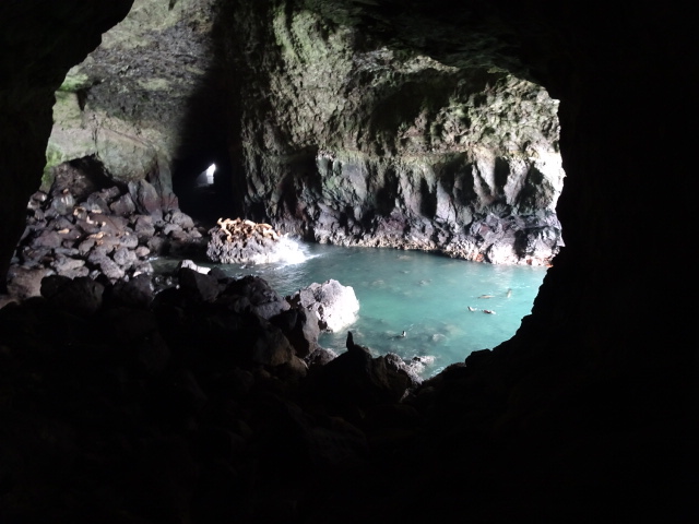
We are now on Day Three of our Grand Western Journey Around These Here United States of America, having just finished our exploration of the Sea Lion Caves, which Jan has dreamt of seeing for over ten years, ever since her sister Mary told her of them.
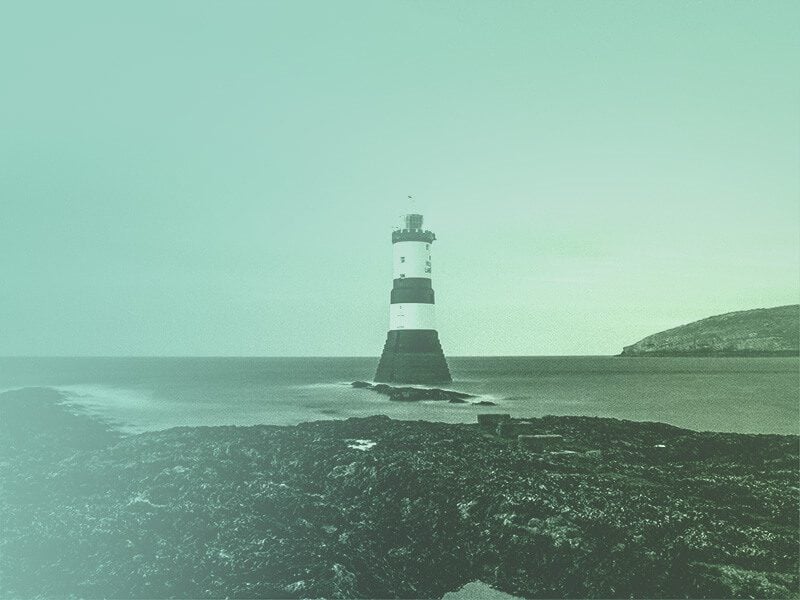
They are like something out of a boy’s dream. A secret cave, invisible from the steep rocky cliff and open to the sea, where hundreds of huge sea lions, as well as gulls, cormorants, and guillemots (black and white birds a bit like a seafaring pigeon) shelter in the winter and spring. We had the splendid treat of watching 40 to 50 ginormous sea lions (bulls=1200-1500 pounds/cows=700 lbs) leap off the rock they were resting on and rush out of the cave into the open water beyond. This is the largest mainland sea cave in North America. It is formed by two natural volcanic fissures created 25 million years ago and then hollowed out by the action of the sea. It is huge! It was discovered and explored in 1880 by a Captain Cox, which is just the sort of name for a cave explorer/sea captain.
(“Skunk cabbage!” remarks Jan excitedly as we zoom down 101 while I write this. She likes skunk cabbage and has remarked on it every time we see it. It is a stinky wetland plant with large flat leaves and a bright yellow flower that, yes, smells like skunk, a common sight in the soggier parts of this soggy ecozone that extends from California to British Columbia all along the west side of the Cascades to the Pacific. And given that the Pacific is currently pounding the basalt and granite cliff dropping precipitously away from my passenger window, there is a lot of wetland.)
Anyway, we started on Monday and, as I expected, met with the unexpected: a non-functional Garmin doohickey that required a software update. The plan had been to leave in the morningish, but with one thing and another, we actually started a bit after noon. Filled with the exhilaration of new beginnings and the Spirit of Adventure, we said a prayer, commended ourselves to the care of Almighty Providence, and drove exactly one mile to the McDonald’s, where we realized that the Garmin Lady had no idea where anything was. Since knowing where things are is her sole function, we decided to take advantage of the wifi conveniently located at our house, which was only one mile away at that point.
So, thank Almighty Providence for that, we headed back home, logged on, figured out how to download all the updates to Garmin via this here computer I’m typing on, gave the Garmin Lady a big ol’ brain full of all knowledge of every road in America there is, and headed off again still covered by all the prayers we had previously offered.
This time, we got as far as the Edmonds Ferry, some five miles from Chez Amis, where dwelleth the Family Shea. We got in line, had a lovely half our nap there by the shores of Puget Sound, painfully disappointed that neither of us qualified for Old People Ferry Discounts, but able to console ourselves with the thought that Jan’s Genuine Senior Citizen Eterna-Pass will henceforth and to the end of her days get us, free of charge into every National Park in the US: something we plan to exploit with brutal efficiency on this trip.
Finally, about 3:10, we boarded the ferry, 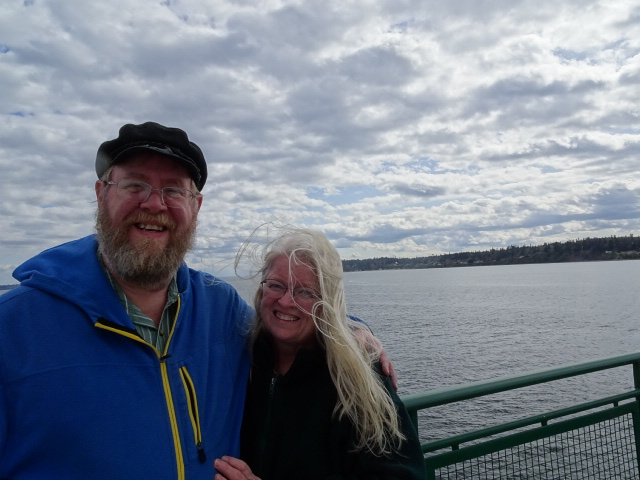 dimly aware that it was not precisely the 9:00 AM crossing we had initially aimed for. Accessing the Garmin Brain of All Geographic Knowledge, we performed our first calculation and the All Mother Orb of Garminology revealed to us that we would now not arrive at Cape Flattery (way out on the far corner of the Olympic Peninsula—the most northestwestiest place you can be in the lower 48 and therefore Cool) until 7:00 PM. This seemed to us sub-optimal.
So instead we opted to head directly to the home of Jan’s sister Kathleen and her husband Chris in Raymond, WA. So we headed down Highway 3, south on the Kitsap Peninsula. Garmin kept commanding us to take various exits so that we would (apparently) be parallel to 3. No idea why. We ignored and eventually Garmin capitulated to our will, as good little machines should. We guess she was trying to spare us Bremerton traffic. (She’s taken on us on weird side jaunts since. Weird.)
Anyway, got to Kathleen’s and had a *fantastic* seafood dinner of sea perch, oysters, crab, and shrimp. Chris has both access to beaucoup seafood and amazing cooking chops. So we ate like kings Monday night and had some of Jan’s Russian cream for dessert. Chris also introduced us to an odd 90s show called “Eerie, Indiana” about this kid that lives in a creepy town where strange things happen. It was pretty fun.
Jan and Kathleen chatted merrily for the rest of the evening and Chris hit the hay early. Jan and I plugged in the CPAPs and konked out, sleeping quite well (I have a charism of sleeping and use it for good, not for evil).
Next morning, after a lovely refreshing shower, I emerged from the bedroom to find Jan and Kathleen working on their second or third cups of tea and the heavenly scent of bacon in the air. Yes, Chris was cooking again. Omelets this time and, again, awesome.
After that we bid them farewell, and hit the road about 10:30 or so. Our first objective was Dismal Nitch. 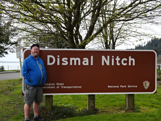 It’s basically a rest stop just a few miles from the mouth of the Columbia. But it is super cool because the name was given it by Lewis and Clark, who were stuck there November 8-15. 1805. It’s basically an exposed concave bank on the north side of the Columbia River where they and the Corps of Discovery weathered a ferocious winter storm and were miserable for a week (hence the name).
Jan and I both enjoy local place names and read them off to each other as we tootle down the road (“Slaughterhouse Lane!” she says, as if in confirmation as I type this. “Skunk cabbage!” she adds, like the weirdo she is.) Dismal Nitch therefore had a natural attraction for both of us.
A few miles further down the road we came to the mighty Astoria Bridge that crosses the Columbia almost at the mouth. It’s gotta be five miles wide there. We cheered as we drove under the Oregon border sign then headed for Fort Clatsop, which is where L&C wintered in January 1806. I learned to identify Sitka Spruce there with my plant and critter-loving sweetie, who always loves to learn about new things (Sitka Spruce has scaly bark). They have a reproduction of the Fort L&C built, based on Clark’s journals. The mission of the grandly-named Corps of Discovery was to find out what on earth Jefferson had just bought with the Louisiana Purchase and, above all, figure out if there was indeed some kind of Northwest Passage that would open an easy trade route to Asia (turns out there wasn’t, what with the Rocky Mountains in the way. But they still managed to cross the continent, find the Columbia, and make their way to the Pacific, thanks to their incredible courage and skill, and the extremely useful help of Sacagawea, a Native woman and French trapper’s wife who not only gave birth on the trip and brought the baby with her, but who helped multiple times to negotiate with the local folk along the way (traveling with a woman and child was a helpful token that you were not looking for a fight)).
Anyway, after Fort Clatsop, we headed south (our basic trajectory for the next few days) and Jan took the wheel because, oh bliss!, I felt like taking a nap and just… could! So off we went to Cannon Beach while I just leaned my chair back and konked.
Before I knew it, we were there! Cannon Beach is a combination of El Touristaville–lots of posh, spendy little shops where disciples of Gwyneth Paltrow buy Essential Oils and undergo cleansings, purges, and chakra alignments—and summer community for the super-rich. The beach itself is a broad, flat expanse of sand edged by white sand dunes, grass hissing in the perpetual wind, and gray, shingle-covered houses that look like New England.
There were surprising numbers of people out for a Tuesday in April, as there had been at Fort Clatsop. Jan and I speculated that this might be due to Spring Break or Easter week for Catholic kids—or both. Kites and frisbees sailed through the air and lots of people (including us) had their pictures taken with the great natural wonder that punctuates the beach: Haystack Rock.
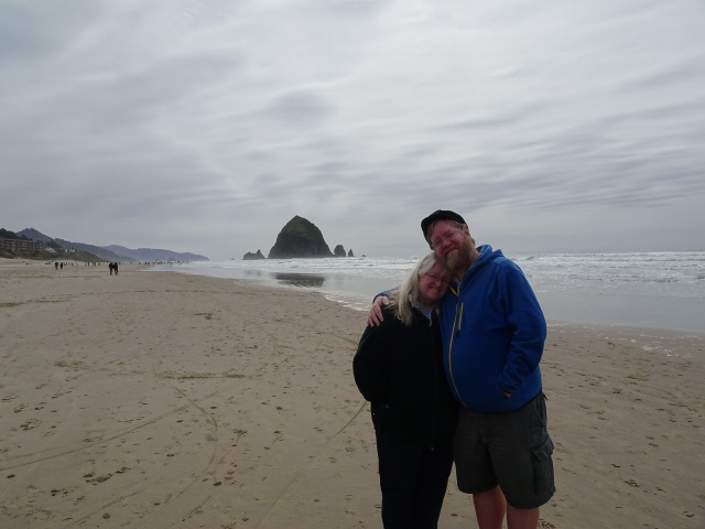
We spent a good hour and a half strolling the beach. It was so unlike beaches in Puget Sound, which are unfailingly rocky. This was a proper beach, another gift of the Columbia since the sand is the fruit of millions of years of erosion from the Washington/Idaho interior. Haystack Rock is this immense chunk of volcanic rock sitting maybe 100 yards offshore. It serves as a rookery for seabirds and, no doubt, for sea lions. Grumpy old Luke Skywalker would live on it if he could.
Eventually, Jan and I realized we needed to hit the road to get to our campsite, so we mosied back to our car, fired up the Garmin and blasted off, stopping at a Denny’s to spare ourselves the annoyance of having to cook in the dark since we would not attain our goal till 7:30 or so.
Sleeping was a challenge since it turned out I can’t *quite* stretch out to full length and turning off the heat on the CPAP makes the air *really* cold. The CPAPs are running off a Marine battery that we plug into the cigarette lighter to recharge while we drive. We will find out whether we win or lose the horse race on drain/recharge as the journey progresses.
The folks camping near us turned out be doing the same thing we were, except they left from Minnesota and had come through the Dakotas, Montana, Idaho, Washington and were now going south.
This morning, we awoke (having hit the hay by 8) at about a quarter of 7. Jan was chilled from the trip to the bathroom and so got a hot breakfast going (hot cocoa and Shea McMuffins). It tasted like heaven there in the woods by the beach. Then we packed up our little kitchen and hit the road at 8, arriving at the Sea Lion Caves by 8:30.
After the Caves, we decided to make for Crater Lake, which is basically all we have been doing since. Garmin, who Knows, prophesies we will arrive about 6 PM. That’s 3 and a half hours from now.
When I hit a McDonalds or Starbucks, I will post this. But for now, I’m gonna savor the mountains somewhere west of Roseburg and sing “Wondrin’ Where the Lions” are along with Bruce Cockburn and the woman I love.
Coming soon: Crater Lake: Our Private Property (and Other Adventures in Poor Planning)