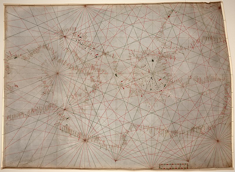
In the 13th century, so-called “portolan maps” appeared that are so accurate, they could be used in navigation today. But it has been a mystery how they were made and how, given the limits in technology of the time, they could be so accurate. (This is another example of how the notion that people from other times were unintelligent is just untrue, as in the myth that people in the Middle Ages thought the earth was flat.) A mathematician has figured out at least part of the answer of why these hand-drawn maps are so good, with even their limitations pointing to a startling sophistication.
From Julie Rehmeyer, The Mystery of Extraordinarily Accurate Medieval Maps | DiscoverMagazine.com:
One of the most remarkable and mysterious technical advances in the history of the world is written on the hide of a 13th-century calf. Inked into the vellum is a chart of the Mediterranean so accurate that ships today could navigate with it. Most earlier maps that included the region were not intended for navigation and were so imprecise that they are virtually unrecognizable to the modern eye.
With this map, it’s as if some medieval mapmaker flew to the heavens and sketched what he saw — though in reality, he could never have traveled higher than a church tower.
The person who made this document — the first so-called portolan chart, from the Italian word portolano, meaning “a collection of sailing directions” — spawned a new era of mapmaking and oceanic exploration. For the first time, Europeans could accurately visualize their continent in a way that enabled them to improvise new navigational routes instead of simply going from point to point.
That first portolan mapmaker also created an enormous puzzle for historians to come, because he left behind few hints of his method: no rough drafts, no sketches, no descriptions of his work. “Even with all the information he had — every sailor’s notebook, every description in every journal — I wouldn’t know how to make the map he made,” says John Hessler, a specialist in modern cartography at the Library of Congress.
But Hessler has approached the question using a tool that is foreign to most historians: mathematics. By systematically analyzing the discrepancies between the portolan charts and modern ones, Hessler has begun to trace the mapmaker’s tracks within the maps themselves.