I am presently working on a History of the United States. My only minor problem is that I am far from sure that such an effort is possible, or at least without a great many cautions and caveats. Put crudely, I don’t know any more where the country begins or ends. Let me explain.
Back in 1997, I published the first edition of a History of the United States, which has been successful mainly in Britain and Europe (it has been translated into eight languages). I am now doing a sixth edition, which is so extensive a revision that it is close to a new book: a whole lot has happened in history writing over the past generation or so. History just keeps on happening.
An Inevitable Nation?
But at least I know the book’s main subject, right? I know the canvas on which to paint a picture? Well, that’s the problem. I know what the shape of the United States is today, and that is roughly what it has been since the mid-nineteenth century, if we allow for the changing roster of states, and the admission of such new territories as Alaska and Hawaii. We easily identify the Lower Forty-Eight, which includes cities like Phoenix and New Orleans and Seattle. But if I am writing a long-term history from the eighteenth century, what do I do about the places that would become Phoenix and New Orleans and Seattle? Do I neglect those areas until the blessed day when they officially fall under US sway? Or do I find some way of describing events and origins there as a kind of prehistory of US power?
Either way, it is exceedingly hard to tell the story except in a backward looking way. To invoke a technical term, it is teleological, writing in terms of what is assumed to be the natural goal or end of the process.
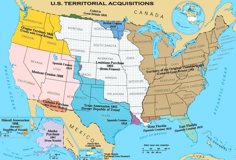
Reinforcing that vision is the sense of inevitability that presumes that the Lower Forty-Eight was always destined to exist, and in very much its historic form – within what we think of as its natural boundaries. The stereotypical story is well known. The USA naturally absorbed the French territories in the Louisiana Purchase, then the Mexican lands, and then Alaska. Those Native peoples who happened to exist within those natural boundaries put up a resistance that was stubborn and inconvenient, but they stood no chance against the weight of American destiny. In 1845, John L. O’Sullivan famously justified American claims to the whole of the Oregon territory, disputed with Great Britain: “And that claim is by the right of our manifest destiny to overspread and to possess the whole of the continent which Providence has given us for the development of the great experiment of liberty and federated self-government entrusted to us.”
All too often, our US histories look like a map on a television documentary, with an illuminated core region along the east coast, which spreads swiftly and inevitably over those hitherto dark regions, which in turn become lit up as they achieve their authentic destiny of being included in that United States. The problems with such an account are legion, not least in the overwhelming emphasis on that East Coast core which is, of its nature, white (or white-ruled), Protestant, and Anglophone: this is the “our” in O’Sullivan’s rhetoric.
Natural Frontiers?
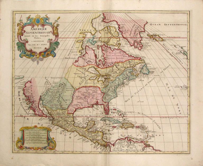
Scarcely less fraught is the question of geography, and the exact scope of the lands on which this whole American story would develop. That whole idea of “inevitability” is very shaky indeed. If we look for instance at a map of North America as it existed in 1800, then with the benefit of hindsight, we know that Louisiana and Texas and Florida would eventually be incorporated into the United States, while other regions such as Northern Mexico or Upper Canada (Ontario) or Cuba would not. In that case, it would make sense to include accounts of pre-US conditions in Texas, say, but not in Ontario. (The map above is actually from 1792, but that is close enough).
But such expectations were by no means obvious at the time. It is very easy to imagine scenarios when the USA would have acquired a very different shape, and this is no mere issue of speculative alternative history. We are dealing with what well-informed people believed or hoped in those earlier eras.
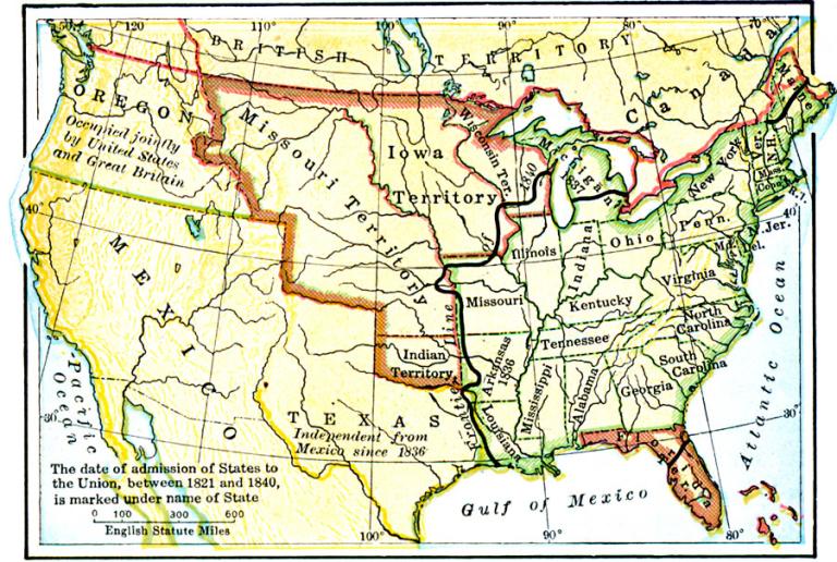
It was far from obvious to contemporary observers that the United States would have resisted multiple serious efforts at secession or partition, which of course reached their peak during the 1860s. In retrospect we know that the nascent Confederate States of America would not persist as a major New World power, or that the United States of America would be confined to the north-east and Midwest; but Abraham Lincoln could not take that fact for granted.
Which Natural Northern Frontier?
Nor were the country’s external limits fixed or predetermined. Although we often speak of the “continental United States,” that nation actually occupies only a portion of the larger North American continent. From the colonial period, Americans could at least dream of expanding to the Pacific Coast as a natural western boundary. The royal charter granted to the colony of Connecticut in 1662 defined its territories as running from “Narraganset-Bay on the East, to the South Sea on the West Part” – that is, extending a line of latitude all the way to what we call the Pacific. In 1732, the royal charter for the new colony of Georgia likewise proposed a border running “in direct lines to the South Seas.” Early national leaders had high hopes of such a transcontinental leap for the whole United States, although they differed on a possible time scale – would it take decades, or centuries? In contrast, northern frontiers were particularly subject to debate, and no such natural limits presented themselves.
For much of American history, many Americans were thoroughly convinced that the lands that became Canada would inevitably fall into the possession of the United States. That was a real prospect during the War of 1812, and frequent later tensions between the USA and Great Britain made it highly likely that Canada would be a theater for American conquest and annexation. Naval and imperial rivalries appeared to make warfare certain, as did U.S.-Canadian border rivalries. I have already mentioned the frontier disputes in the Oregon Territory in the 1840s, which stirred American war fever. Between 1840 and 1900, serious war scares flared roughly once per decade, with a particular intensity in the 1890s. It was in 1895 that Theodore Roosevelt notoriously proclaimed that “Let the fight come if it must. I don’t care whether our seacoast cities are bombarded or not. We would take Canada.”
Contemporaries took that prospect very seriously, however civilly individuals behaved to each other. In that frightening year of 1895, Mark Twain was doing his global tour of the British Empire, and as he wrote with some amazement, in Following the Equator: “The war-cloud hanging black over England and America made no trouble for me. I was a prospective prisoner of war, but at dinners, suppers, on the platform, and elsewhere, there was never anything to remind me of it. This was hospitality of the right metal, and would have been prominently lacking in some countries, in the circumstances.”
Of course, US victory in such a struggle was by no means inevitable, and the War of 1812 could easily have had a different outcome, as could diplomatic negotiations. As it turned out, the US gained more than the British in the Treaty of 1818, which settled the 49th Parallel as a border, but that was not a foregone conclusion. (See Benjamin Hoy, A Line of Blood and Dirt: Creating the Canada-United States Border across Indigenous Lands (Oxford University Press, 2021). If matters had developed differently over the following century, perhaps the US could have lost significant border regions to British control, including much or all of the Pacific north-west.
Just how late such concerns survived is startling. In the 1920s, the US planned a full scale invasion of Canada as part of its highly detailed War Plan Red, which envisaged a global conflict against a potent alliance of Britain and Japan. U.S. forces ultimately planned to seize Canada’s rich mineral resources around Sudbury, Ontario, but in the opening phases of conflict, they would launch surprise attacks on the key ports of Halifax and Vancouver. That scheme remained on the books until 1939.
If matters had developed only a little differently at multiple points between 1830 and 1930, then the US’s natural northern frontier would have been the Arctic Circle, rather than that nice neat 49th Parallel, as God evidently planned it. That would incidentally have created the world’s largest nation in terms of land area, bigger than modern Russia.
Which Natural Southern Frontier?
Southern frontiers were no less subject to historical might-have beens. In the Antebellum period, visions of new slave-owning territories encouraged the activities of filibusters who hoped to draw Caribbean and Central American lands into the US orbit, and quite possibly as new states. Well into the twentieth century, the US operated tight de facto control over several nations, including Cuba, Haiti and Nicaragua, although formal annexation was never a real prospect.
Nor need the US borders have been as expansive as they actually were. The Texas Revolution could easily have collapsed (and it very nearly did so), potentially leaving the southern border of the later US at the Red River rather than the Rio Grande. To see just how close that struggle was, see Sam W. Haynes, Unsettled Land: From Revolution to Republic, the Struggle for Texas (Basic Books, 2022). In that scenario, would the Mexican War of the 1840s have developed in anything like the form that it did?
Further west, in the US reality that we know, the Lower Forty Eight includes Tucson and southern Arizona, but not portions of the Mexican states of Sonora and Chihuahua. That border reflects an agreement signed in 1854, the Gadsden Purchase, and a slightly divergent history might well have located that border somewhat further north or south. Providence need not have been so precise in granting all those Western lands to the US.
Who are you calling “inevitable”?
Widening and Narrowing the Story
Leaving aside such speculations, our tendency to push the US’s “natural frontiers” into the remote past can cause real tunnel vision, seeing borders where none existed in those earlier eras. Examples abound. Even when telling the astonishing story of the Native peoples of the south-west, the so-called Anasazi and related groups, many archaeological books still assume a border that separated those cultures from a spectacular Mexican site like Casas Grandes, with which they were undoubtedly connected. If there is a border now, there must always have meant to be one…
Most histories of the United States begin with a section on early exploration and settlement, which may include the Spanish settlement of Florida, but it will definitely mention the wanderings of Cabeza de Vaca through Texas and the southwest (1528-36) and the adventures of the later Coronado expedition (1540-1542) across the southwest and into Kansas. I certainly do that in my own History. But the reason we describe these enterprises rather than others in the New World is that some day in the far future, those territories will be part of the United States. Conversely, those same “American” histories may or may not say much about Jacques Cartier’s exploration of the St. Lawrence in the same era, and the early days of Montreal and Québec, because we know with equal certainty that these were destined to be part of Canada. We are thinking, and writing, backwards.
I was struck by a line in John T. Ellisor’s book The Second Creek War: Interethnic Conflict and Collusion on a Collapsing Frontier (University of Nebraska Press 2010). By way of background, the author describes Andrew Jackson’s activities during the First Seminole War of 1818, which, as the author says “was in essence merely a continuation of the colonial revolt called the First Creek War.” That conflict, which occurred in 1813-14, agitated the frontier territory in Alabama and along the Gulf Coast. But I initially found the language surprising. What do you mean “colonial”? Alabama isn’t a colony! It is, and always was meant to be, one of the Lower Forty-Eight states. Right? But in the context of the time, and avoiding 20-20 hindsight, this clearly was a colonial struggle, on the fringes of an expanding empire.
Most Things Are Never Meant
Philip Larkin’s poem “Going, Going” includes a line that can be a salutary reminder to historians of many times and places: “Most things are never meant.” The idea of Manifest Destiny makes us assume that some places were always intended to be American, Providentially so, and that is troubling in its own right. No less serious, it causes us not to pay due attention to other places that were intimately connected to the American story, because they happened to fall outside the borders of the United States as it emerged.
And those borders were in no sense Providential. Nor Manifest.
More next time.
To understand one of the various crises that brought Britain and the US to war, see Amanda Foreman, A World on Fire: Britain’s Crucial Role in the American Civil War (Random House, 2011).