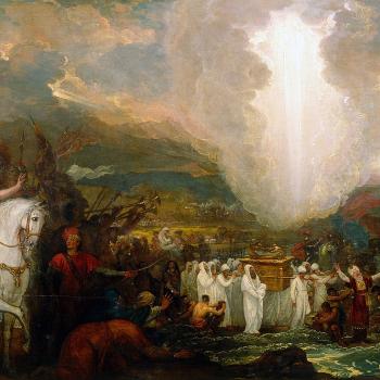
And Which Specific Body of Water Did They Cross, According to the Combined Deductions and Determinations of the Bible and Archaeology?

Egyptologist James K. Hoffmeier sets the background for the discussion:
Some passages call the sea in question simply “the sea” (hayyam) (Exod. 14:2, 9, 16, 21, 23; 15:1-4; Num. 33:8; Ps. 78:13). In other texts, yam sup is used in the Hebrew (MT) [Masoretic Text] of Exodus 13:18; 15:4b, 22; Joshua 2:10; 4:23; Psalm 136:13, 15. Sup clearly means reeds or rushes, as can be seen in Exodus 2:3 when the mother of Moses places him in a basket among the reeds (sup) on the Nile’s shore. Isaiah 19:6 also mentions reeds (sup) in the Nile. In the Septuagint, the Greek translations of the Holy Bible, sup is rendered as eruthra, “red,” and this is the tradition followed in the Latin Vulgate, where the sea is called mari Rubro. Most English translations have followed this translation tradition . . . There is no convincing explanation for why the Greek translators did not literally translate sup, although it might have been their aim to locate the sea at the place they thought the text was indicating, that is, the Red Sea, the present day Gulf of Suez w Aqaba. (1)
It is an exceedingly odd thing that English Bibles almost unanimously translate sup (or suph) as “red.” The lexicons are quite clear as to its meaning. Strong’s Concordance‘ literal definition for it is “reeds, rushes.” (2) Brown-Driver-Briggs states:
reeds, rushes (collective) (probably loan-word from Egyptian . . .); —
1 rushes, in Nile Exodus 2:3,5 (E); קָנֶה וָסוּף Isaiah 19:6 (of Egypt).
2 usually in combination יַםסֿוּף probably = sea of rushes or reeds ( > sea of (city) Suph), which Greek included in wider name θάλασσα Ἐρυθρἀ, Red Sea (. . .name originally given to upper end of Gulf of Suez, extending into Bitter Lakes, shallow and marshy, whence reeds (probably also reddish colour) . . . name applied only to arms of Red Sea; most often
a. to Gulf of Suez Exodus 10:19; Joshua 2:10 (both J), Exodus 13:18; Exodus 15:4,22; Exodus 23:31 (all E), Deuteronomy 11:4; Joshua 4:23 (D), Numbers 33:10,11 (P), elsewhere late Nehemiah 9:9; Psalm 106:7; Psalm 106:9; Psalm 106:22; Psalm 136:13; Psalm 136:15.
b. sometimes to Gulf of Akaba 1 Kings 9:26, and דֶּרֶךְ יַםסֿוּף Numbers 21:4 (E), probably also Numbers 14:25 (E), Deuteronomy 1:40; Deuteronomy 2:1; perhaps Judges 11:16; Jeremiah 49:21; possibly read מִיַּםסֿוּף for ׳מוֺל ס Deuteronomy 1:1 . . . (3)
Note: I disagree (for a hundred reasons) with the defunct and decrepit 19th-century Documentary Theory, which is what the letters J, E, P, and D above are referring to. But for the sake of biblical definition, it’s irrelevant.
Gesenius’ Hebrew-Chaldee Lexicon to the Old Testament never mentions the word “red” at all in its descriptions for Hebrew word #5488 (sup / suph):
(1) rush, reed, sea weed. . . . Specially — (a) sea weed, Jon. 2:6; whence the weedy sea, i.e., the Arabian gulf which abounds in sea weed, Ps. 106:7, 9, 22; 136:13. It is also called in Egyptian the sea of weed . . . (4)
Other Bible references concur:
Cuph means a rush or seaweed such as abounds in the lower portions of the Nile and the upper portions of the Red Sea. . . . But the name yam-cuph, though applied to the whole sea, was especially used with reference to the northern part, which is alone mentioned in the Bible, and to the two gulfs (Suez and Aqabah) which border the Sinaitic Peninsula, especially the Gulf of Suez. . . .
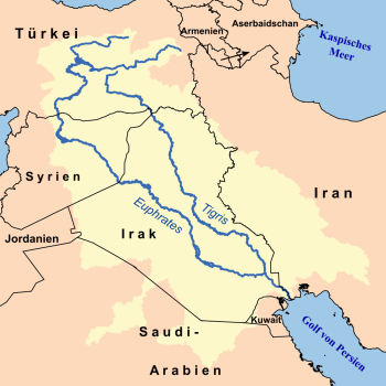
Owing to the lower land levels which prevailed in recent geological times, the Gulf of Suez formerly extended across the lowland which separates it from the Bitter Lakes, a distance of 15 or 20 miles now traversed by the Suez Canal, which encountered no elevation more than 30 ft. above tide. In early historic times the Gulf ended at Ismailia at the head of Lake Timsah. . . .
In recent times it was discovered that the Gulf of Suez formerly extended 30 miles northward to the site of the present Ismailia and the ancient Pithom, . . . with an extension of the waters of the Gulf to the Bitter Lakes and Lake Timsah, . . . the narrative at once so perfectly accords with the physical conditions involved as to become not only easily credible, but self-evidencing. . . .
Three times the wind is mentioned as the means employed by God in opening the water [Exod. 14:21; 15:8, 10]. The competency of the wind temporarily to remove the water from the passage connecting the Gulf of Suez with the Bitter Lakes, provided it was only a few feet deep, is amply proved by facts of recent observation. Major General Tullock of the British army (Proc. Victoria Inst., XXVIII, 267-80) reports having witnessed the driving off of the water from Lake Menzaleh by the wind to such an extent as to lower the level 6 ft., thus leaving small vessels over the shallow water stranded for a while in the muddy bottom. According to the report of the Suez Canal Company, the difference between the highest and the lowest water at Suez is 10 ft. 7 inches, all of which must be due to the effect of the wind, since the tides do not affect the Red Sea. The power of the wind to affect water levels is strikingly witnessed upon Lake Erie in the United States, where according to the report of the Deep Waterways Commission for 1896 (165, 168) it appears that strong wind from the Southwest sometimes lowers the water at Toledo, Ohio, on the western end of the lake to the extent of more than 7 ft., at the same time causing it to rise at Buffalo at the eastern end a similar amount; while a change in the wind during the passage of a single storm reverses the effect, thus sometimes producing a change of level at either end of the lake of 14 ft. in the course of a single day. It would require far less than a tornado to lower the water at Cheloof sufficiently to lay bare the shallow channel which we have supposed at that time to separate Egypt from the Sinaitic Peninsula. . . .
On the explanation we have given the transaction it is what Robinson felicitously calls a mediate miracle, that is, a miracle in which the hand of God is seen in the use of natural forces which it would be impossible for man to command. If anyone should say that this was a mere coincidence, that the east wind blew at the precise time that Moses reached the place of crossing, the answer is that such a coincidence could have been brought about only by supernatural agency. . . . The opening of the sea may have been a foreordained event in the course of Nature which God only foreknew, in which case the direct divine agency was limited to those influences upon the human actors that led them to place themselves where they could take advantage of the natural opportunity. (5)
This explanation was followed almost to a tee by Carl Drews, who has a Master of Science degree in atmospheric and oceanic sciences. He wrote about his theory (written about in scientific peer-reviewed journals) of a “wind setdown” that could possibly explain the biblical parting of the sea in terms of natural events. I wrote about his theory The Word Set in Stone: How Archaeology, Science, and History Back Up the Bible (Catholic Answers Press: March 2023 [read this excerpt]) on pages 110-114.
Drews even uses the example of Lake Erie, like the above article from 1939 does, and mentions the 1882 report of British Major General Tullock. It leads me to believe that the article above likely provided the initial impetus for his theory: now more scientifically corroborated. Drews also holds that the crossing occurred in the lakes north of the Gulf of Suez and south of the Mediterranean Sea, “at the north end of the Suez Canal in one of the shallow lagoons . . .” Now I have shown in biblical and linguistic reference works (especially Brown-Driver-Briggs) that the biblical description “Red Sea” can also refer to these lakes. The New Bible Dictionary (6) can be added to the list of these sources:
In the Old Testament, the term yam sup, ‘sea of reeds’ (and/or ‘weed’), is used to cover: (a) the Bitter Lakes region in the Egyptian Delta north of Suez along the line of the present Suez Canal . . .
From the ‘sea of reeds’, yam sup, Israel went into the wilderness of Shur (Exod. 15:22; Num. 33:8) and then on towards Sinai. Various points suggest that this famous crossing, the Exodus in the narrow sense, took place in the bitter lakes region, roughly between Qantara (30 miles south of Port Said) and just north of Suez. First, geographically, the wilderness of Shur, which Israel entered directly from crossing the yam sup (Exod. 15:22), is opposite this very area. Secondly, geophysically, the reedy waters of the Bitter Lakes and Lake Menzaleh can be affected by strong east winds precisely in the way described in Exodus 14:21 and experienced on a small scale by Aly Shafei Bey in 1945-6 . . . (7)
And another standard source concurs:
In the Old Testament Heb. yam sup is used for the Gulf of Aqabah . . ., the Gulf of Suez . . ., and the sea crossed by the Israelites as they left Egypt (e.g., Exod. 15:4, 22; Deut. 11:4; Josh. 4:23; 24:6; Neh. 9:9; Ps. 136:13, 15). The exact location of the last of these is uncertain, and scholars have variously proposed the bitter lakes region, Lake Menzaleh, Lake Sorbonis, and the Gulf of Suez as possible sites. . . .
An Egyptian text refers to the “papyrus marsh” near the city of Rameses, which is thought by many to be the body of water crossed by the Israelites (cf. Num. 33:5-8). (8)
Kitchen adds, regarding this “papyrus marsh” that the location “par excellence,” would be the north-east part of the Delta between Tanis (Zoan), Qantir, and the present line of the Suez Canal north of Ismalia, on the former Pelusiac arm of the Nile.” (9)
With this extensive background introduction, let’s now see how James K. Hoffmeier brings to the topic fresh archaeological research, in his book, Ancient Israel in Sinai, published by Oxford University Press in 2005. He writes:
Yam sup is situated in the northeastern Delta. Further support for this location is found in the eighth plague of Exodus 10. Locusts infest the land and are only removed when a strong wind from the west drove the hordes of locusts into yam sup ((Exod. 10:19). . . . the starting point of the exodus and the epicenter of the plagues was in the region of Pi-Ramesses/Avaris . . . So when the Bible describes the wind from the west driving the locusts east toward the Sea of reeds, that is, yamma sup, it is referring to the only major body of water east of the Ramesses region, the el-Ballah Lakes, . . . directly to the east. (10)
I provisionally suggested [in his 1996 book, nine years earlier] that Lake Timsah might have been yam sup. But . . . Exodus 14:2 [“. . . turn back and encamp in front of Pi-ha-hiroth, between Migdol and the sea, in front of Baal-zephon . . .”] demands a turn away from the Tjeku (Succoth) and Lake Timsah areas, and requires a movement north, which should eliminate both Lake Timsah and the Bitter Lakes from being candidates for the sea of crossing. (11)
Hoffmeier provides more argumentation for his contention that the el-Ballah Lakes were the place of the extraordinary crossing escape of the Hebrews:
Bietak . . . suggested that p3 twfy corresponded to yam sup of the Exodus tradition. (12) He reaffirmed this interpretation in a recently published map, maintaining that p3 twfy is to be identified with the Ballah Lakes. (13) . . .
Today, the Ballah Lakes are gone, and desert sands, especially in the area east of the Suez Canal, cover its ancient depression . . . Beginning in 1995, excavations at this site uncovered the remains of a harbor with quays where boats docked, and a stone corniche that marked the water’s edge. These discoveries demonstrate that two thousand years ago a lake large enough to handle trading vessels flourished. The geological research of the east Frontier Archaeological Project in 2001 produced evidence that the lake probably extended six to eight kilometers [3.7 to 5 miles] to the north and east of Tell Abu Sefeh during the second millennium B.C. (14)
Clearly, the Arabic elements abu, ab, and bu do represent the ancient Egyptian writing of p3 or pi. And just as Hebrew sup corresponds to Egyptian twf, so does the Arabic suf. Thus the name abu sefeh appears, on solid linguistic grounds, to preserve the ancient Egyptian name ps twfy, and thus it points to the name of the ancient lake on whose shores it was situated, el-Ballah Lake. (15)
Hoffmeier notes after the last citation above that the case would be much stronger if there were evidence as to the locations of the place-names Pi-hahiroth, Migdol, and Baal-Zephon, mentioned in Exodus 14:2 as being near the “sea” in question. After a fascinating 20-page examination of recent archaeological findings, Hoffmeier renders his professional “conclusion”:
What this investigation of p3 twfy (yam sup) and the place names associated with it in Exodus 4:2 demonstrates is that the author has a specific location in mind and that the terms correspond best to Egyptian toponyms of the thirteenth century B.C. . . . Here the case of Migdol/Magdalu is germane. It is attested in several thirteenth- and twelfth-century B.C. Egyptian sources, in the Hebrew prophets (sixth century), and in Greco-Roman-period texts. . . .
he toponyms of Exodus 14:2 have a specificity that was certainly not necessary for a writer inventing the story . . . If P were historicizing an original mythic version of the sea-crossing episode, he did a remarkable job of identifying toponyms known in New Kingdom Egypt, and they fit into a geographical zone that accords well into the generally wet paleoenvironmental situation of the late second millennium B.C. I conclude, therefore, in the light of the new archaeological and paleoenvironmental data presented here, that the geographical setting of Exodus 14 is the area between the north side of the el-Ballah Lake system and the southern tip of the eastern lagoon (i.e., the proposed location of Migdol). By P’s day (fifth century B.C.), this area had radically changed. The Pelusiac had migrated fifteen to twenty kilometers [9 to 12.5 miles] to the north . . .
From a phenomenological perspective, the evidence adduced here demonstrates that the theophany of the sea crossing occurred in a specific geographical location and at a particular time in history. (16)
Manfred Bietak also brings up another important consideration: “The only way of avoiding border control was to cross the Ballah Lakes . . .They are the likeliest contender for the Yam Suph . . .” (17)
Moshier and Hoffmeier stated with even more confidence in 2015,
The archaeological and geological investigations we conducted in northern Sinai between 1998 and 2008 . . . supports the identifications Gardiner and Bietak proposed, viz., that P3-twfy of Ramesside Period texts and yam sup of the Exodus narratives should be identified with the Ballah Lake system . . . (18)
Hoffmeier further noted in 2008:
While the region east of the Delta today is largely desert, satellite images show the outlines of two ancient lakes. The southern one, Ballah Lake, actually contained water till the mid-nineteenth century when the Suez Canal was dug, draining it of its water. The dimensions of the ancient lake wee approximately 12 miles (20 km) long and 9 miles (15 km) at its widest point. Along with a team of geologists, I have been engaged in recent investigation of these ancient lakes. Study at the north end of Ballah Lake shows that it could have reached a depth of 15 to 18 feet (5 to 6 m). The second lake is situated north-east of the first lake and was fed by recently-discovered Nile channels. This lagoon actually emptied into the Mediterranean, the coast of which was much further south in ancient times than it is today. . . .
Ballah Lake is located 21 miles (34 km) directly east of the ancient site of Pi-Ramesses. (19)
At this juncture, my “money” is on the research and conclusions of Hoffmeier: the Egyptologist with two books published about Israel and Egypt by Oxford University, and who has been doing field research in the Nile Delta for many years.
And he concludes that the “Red Sea” crossing occurred at the Ballah Lakes. This scenario is perfectly consistent with Drews’ research on wind setdown natural occurrences that could explain the extraordinary event. It has actually been observed to more or less extent, two times in the region. And Drews’ scientific observations explain how it works, with other examples from Lake Erie. Everything increasingly fits together with regard to this topic. And it confirms (for the zillionth time) the amazing historical and geographical accuracy of the Bible.
FOOTNOTES
1) James K. Hoffmeier, Ancient Israel in Sinai: The Evidence for the Authenticity of the Wilderness Tradition (Oxford University Press, 2005), 81.
2) Bible Hub, “5488. suph.” That is, Strong’s Hebrew word #5488. https://biblehub.com/hebrew/5488.htm.
3) Ibid.
4) William Gesenius, Hebrew-Chaldee Lexicon to the Old Testament, translated by Samuel Prideaux Tregelles (Samuel Bagster and Sons, 1847; reprinted by Baker Book House [Grand Rapids, Michigan] in 1979), 581; coded to Strong’s Hebrew word #5488.
5) George Frederick Wright, “Red Sea,” in James Orr, ed., International Standard Bible Encyclopedia (Grand Rapids, Michigan: Wm. B. Eerdmans Publishing Co., 1939). https://www.internationalstandardbible.com/R/red-sea.html.
6) Kenneth A. Kitchen, “Red Sea,” in J. D. Douglas, ed., The New Bible Dictionary (Grand Rapids, Michigan: Wm. B. Eerdmans Publishing Co., 1962), 1077-1078.
7) See Aly Shafei Bey, Bulletin de la Societe Royale de Geographie d’ Egypte, XXI, August 1946, 231 ff.
8) “Red Sea,” in Allen C. Myers, ed., The Eerdmans Bible Dictionary (Grand Rapids, Michigan: Wm. B. Eerdmans Publishing Co., 1987), 876.
9) Kitchen, 1078.
10) Hoffmeier, 82.
11) Hoffmeier, 86.
12) Manfred Bietak, Tell el-Dab’a (Vienna: Osterreichischen Akadamie der Wissenschaffen Wien, 1975), 2: 137. See also Bietak, “Comments on the Exodus,” in Egypt, Israel, Sinai: Archaeological and Historical Relationships in the Biblical Period, ed. A. F. Rainey (Tel Aviv: Tel Aviv University Press, 1987), 167.
13) Manfred Bietak, Avaris: The Capital of the Hyksos: Recent Excavations at Tell el-Dab’a (London: British Museum, 1996), 2.
14) Hoffmeier, 88.
15) Hoffmeier, 89.
16) Hoffmeier, 108.
17) Manfred Bietak, “On the Historicity of the Exodus: What Egyptology Today Can Contribute to Assessing the Biblical Account of the Sojourn in Egypt,” pp. 17-38 in Thomas E. Levy, Thomas Schneider, & William H. C. Propp, eds., Israel’s Exodus in Transdiciplinary Perspective: Text, Archaeology, Culture, and Geoscience (Switzerland: Springer International Publishing, 2015), 27.
18) Stephen O. Moshier & James K. Hoffmeier, “Which Way Out of Egypt? Physical Geography Related to the Exodus Itinerary,” pp. 101-108 in Levy, ibid., 107.
19) James K. Hoffmeier, The Archaeology of the Bible (Oxford Lion Book), 55-56.
***
Practical Matters: Perhaps some of my 4,200+ free online articles (the most comprehensive “one-stop” Catholic apologetics site) or fifty-one books have helped you (by God’s grace) to decide to become Catholic or to return to the Church, or better understand some doctrines and why we believe them.
Or you may believe my work is worthy to support for the purpose of apologetics and evangelism in general. If so, please seriously consider a much-needed financial contribution. I’m always in need of more funds: especially monthly support. “The laborer is worthy of his wages” (1 Tim 5:18, NKJV). 1 December 2021 was my 20th anniversary as a full-time Catholic apologist, and February 2022 marked the 25th anniversary of my blog.
PayPal donations are the easiest: just send to my email address: [email protected]. You’ll see the term “Catholic Used Book Service”, which is my old side-business. To learn about the different methods of contributing, including 100% tax deduction, etc., see my page: About Catholic Apologist Dave Armstrong / Donation Information. Thanks a million from the bottom of my heart!
***
Photo credit: [public domain / Wallpaper Flare]
Summary: Much confusion has arisen from an unfortunate relentless biblical usage of “Red Sea” (should sometimes be “Reed Sea”). I argue for an exact lake of the crossing.